Mannar Fort: Colonial Ruins, Sea Winds and the Island Road to Talaimannar
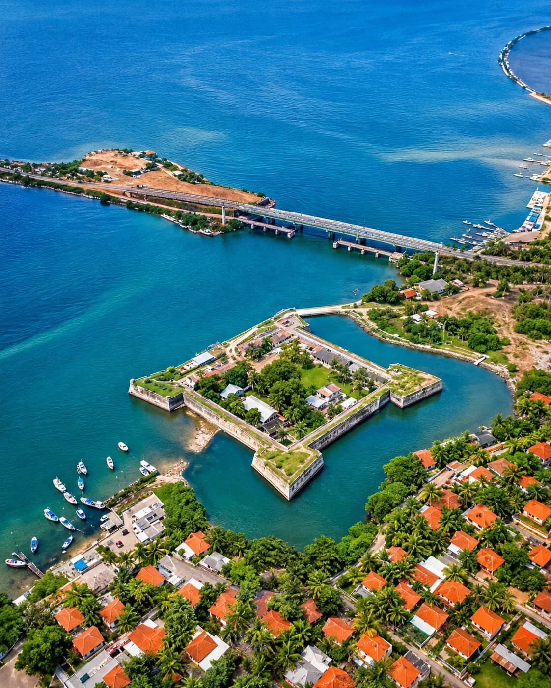
Mannar Fort Sri Lanka is one of the most atmospheric colonial ruins on the island’s northern coast. Standing on Mannar Island, close to the causeway that connects the island to the mainland, the fort looks out across a landscape of sea wind, shallow waters, fishing boats, palms and long northern roads. It does not have the polished heritage-town feeling of Galle Fort or the dramatic military scale of Jaffna Fort. Its beauty is quieter, rougher and more exposed.
For travellers interested in colonial Sri Lanka, Mannar Fort offers a different kind of experience. It is not a busy city monument. It is a coastal ruin shaped by Portuguese ambition, Dutch control, British occupation and the older maritime world of the Gulf of Mannar. Its weathered walls and broken interior remind visitors that colonial Ceylon was not only built around major capitals and ports. It also depended on smaller strategic points that controlled trade, sea routes and local power.
A visit to Mannar Fort is also part of a wider northern journey. From here, the road continues across Mannar Island towards Talaimannar, the windswept edge of Sri Lanka facing India. That island road gives the fort a special sense of place. Mannar feels like a borderland — between land and sea, Sri Lanka and India, history and silence.
Check our Previous article- https://trippingsrilanka.com/stories/jaffna-fort-northern-stronghold
Why Mannar Mattered in Colonial Ceylon
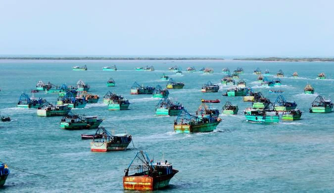
Mannar’s importance came from its location. The island sits near the Gulf of Mannar, facing the narrow sea routes between Sri Lanka and South India. Long before European powers arrived, this region was connected to maritime trade, fishing, pearl banks and movement across the Palk Strait.
For the Portuguese, Dutch and British, Mannar was strategically valuable. A fort here could watch shipping, control local movement and support wider colonial ambitions in northern Ceylon. It was also close to the old pearl fishery zones, which had attracted regional and foreign interest for centuries.
This is what makes Mannar Fort Sri Lanka historically important. It was not built only to defend a small town. It belonged to a larger geography of sea power, trade and northern control. In colonial Ceylon, even a remote-looking island could become important if it sat near valuable waters.
Portuguese Origins: The First Fort at Mannar
The first European fort at Mannar was built by the Portuguese in the 16th century. The Portuguese recognised Mannar’s value as a coastal stronghold and used it to secure influence over the region.
The fort was part of their wider strategy in Ceylon: establish fortified positions, control coastal trade, spread missionary influence and pressure local kingdoms. Mannar was especially important because of its proximity to the Jaffna Kingdom and the sea routes linking the island to South India.
The Portuguese fort was associated with the name São Jorge, or St George. Like many Portuguese strongholds in Asia, it combined military and religious symbolism. Forts were not only defensive structures. They were signs of authority, faith and imperial presence.
For modern visitors, the Portuguese layer is not always easy to separate from later Dutch work. But the origin matters. Mannar Fort began as part of the first European attempt to control the northern maritime edge of Ceylon.
Dutch Capture and Reinforcement
The Dutch captured Mannar Fort from the Portuguese in 1658. This was part of the wider Dutch campaign to remove Portuguese power from Ceylon’s coastal regions. Once in control, the Dutch reinforced and adapted the fort to suit their own military and commercial needs.
The Dutch East India Company was highly focused on trade and strategic coastal control. Forts like Mannar helped protect routes, regulate movement and maintain authority. The fort’s location near the Gulf of Mannar made it useful within the Dutch network of northern and coastal strongholds.
Mannar Fort’s square layout and four bastions reflect the practical military architecture of the period. It was not designed as a large fortified city. It was a compact coastal stronghold, built for observation, defence and control.
British Occupation and Later Decline
In 1795, Mannar Fort passed into British hands after the Dutch surrendered their possessions in Ceylon. Under the British, many older Portuguese and Dutch forts were reused for administrative and military purposes, even if their original strategic importance gradually declined.
Mannar remained part of the colonial map, but the fort no longer held the same level of power it once had. Over time, its internal buildings deteriorated, while the outer walls and bastions survived more visibly.
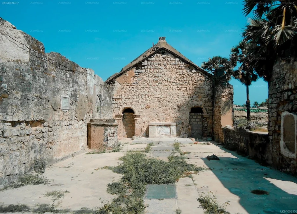
This is part of the fort’s present-day atmosphere. Mannar Fort Sri Lanka is not a fully restored monument. It is a ruin. Its broken buildings, open spaces and weathered masonry give it a stronger sense of age than many more polished colonial sites.
Walking Through the Ruins
A walk through Mannar Fort is simple but memorable. Visitors can observe the outer walls, bastions, arched entrance and ruined internal structures. The fort’s square shape is still readable, and the surviving ramparts give a clear sense of its old defensive purpose.
The interior is where the ruin feels most powerful. Broken walls, roofless structures, stone fragments and open courtyards create an atmosphere of abandonment. Grass and vegetation grow through parts of the site. The sea breeze moves through the open spaces. There is little of the curated heritage experience found in more famous tourist towns.
That roughness is exactly what makes Mannar Fort special. It feels honest. It shows colonial history not as polished nostalgia, but as a weathered remains of power.
The Sea Wind and the Island Landscape
The landscape around Mannar Fort is essential to the experience. The fort stands close to water, palms and open northern sky. The light is harsh at midday and beautiful in the late afternoon. The wind gives the site a restless coastal mood.
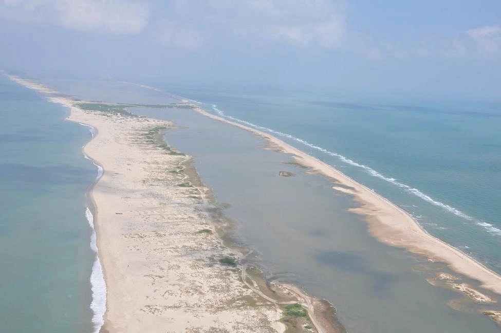
This is not the lush hill country or the crowded streets of Colombo. Mannar belongs to a drier, flatter, more open landscape. The island has its own identity, shaped by fishing, lagoons, salt air, causeways, birds and roads leading towards Talaimannar.
For travellers, this setting makes the fort more than an architectural site. It becomes part of a journey through northern coastal Sri Lanka. The fort, the bridge, the sea and the road all belong to the same story.
The Road to Talaimannar
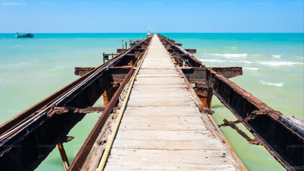
One of the best ways to understand Mannar Fort Sri Lanka is to combine it with the road to Talaimannar. From Mannar town, the route stretches west across the island, passing coastal scenery, dry landscapes, fishing settlements and open horizons.
Talaimannar has long carried a sense of edge and connection. It faces India across the narrow sea, and the wider region is associated with Adam’s Bridge, also known as Rama’s Bridge, the chain of shoals between Sri Lanka and India. This geography gives Mannar a unique place in the island’s imagination.
A trip to the fort followed by the road to Talaimannar turns a short heritage stop into a fuller coastal journey. It allows visitors to feel why this region mattered historically. Mannar was never isolated. It was connected by sea, trade, memory and movement.
Mannar’s Older and Wider Heritage
Mannar is not only colonial. The region has older religious, maritime and cultural histories that give the fort deeper context. The island is associated with ancient trade, pearl fishing, Hindu and Christian religious sites, Muslim communities, fishing traditions and links across the Palk Strait.
The famous baobab tree of Mannar, the shrine of Our Lady of Madhu in the wider district, Thiruketheeswaram Temple nearby and the birdlife of the wetlands all show how layered the region is. Colonial history is only one chapter in a much longer story.
This matters because Mannar Fort should not be viewed as a European relic standing alone. It is part of a northern coastal landscape where many cultures, faiths and routes have met over centuries.
Why Mannar Fort Feels Different
Mannar Fort feels different from Sri Lanka’s better-known forts because it is quieter and less commercially developed. There are no boutique cafés inside the walls, no preserved colonial townscape and no large crowds taking sunset photographs.
Instead, there is space. There is wind. There are ruins and water and the feeling of a place that has survived without becoming a major tourist spectacle.
For offbeat travellers, that is the attraction. Mannar Fort gives you room to think. It allows history to feel open and unfinished. The silence makes the fort more evocative, especially for visitors who enjoy ruins rather than restored monuments.
Best Time to Visit Mannar Fort
The best time to visit Mannar Fort is early morning or late afternoon. The northern heat can be strong, and the open fort offers limited shade. Late afternoon is especially good for photography, when the light softens and the stone walls take on warmer tones.
Visitors should wear comfortable shoes, carry water and be careful when walking through uneven sections. As with all heritage sites, it is important not to climb fragile structures or damage the walls.
Mannar works well as a slow travel destination. Instead of visiting only the fort and leaving, spend time exploring the island, the causeway, Talaimannar, local fishing areas, religious sites and birdwatching spots.
Why Mannar Fort Deserves More Attention
Mannar Fort deserves more attention because it helps complete the map of colonial Sri Lanka. Without places like Mannar, the story becomes too focused on Colombo, Galle and Kandy. The northern coast had its own strategic importance, and Mannar was one of its key points.
The fort also connects many themes: Portuguese expansion, Dutch coastal control, British occupation, pearl fisheries, Gulf of Mannar trade, island roads and the maritime link between Sri Lanka and India.
For history readers, Mannar Fort is valuable because it shows how colonial power worked at the margins. For travellers, it offers an atmospheric and uncrowded heritage experience. For photographers, it offers textures, ruins and coastal light.
Final Thoughts: A Northern Coastal Memory of Old Ceylon
Mannar Fort Sri Lanka is not the grandest colonial fort on the island, but it is one of the most evocative. Its strength lies in its setting and silence. The ruins stand beside the northern waters, close to the island road that leads towards Talaimannar and the edge of Sri Lanka.
To walk through Mannar Fort is to encounter colonial Ceylon in a rawer form. The walls are still there, but the interior has faded. The bastions remain, but the old military purpose has gone. What is left is memory — Portuguese, Dutch, British and deeply coastal.
For travellers willing to go beyond the usual route, Mannar Fort is a rewarding stop. It tells the story of a forgotten northern stronghold, shaped by sea winds, colonial ambition and the long road to Talaimannar.
FAQs About Mannar Fort Sri Lanka
Who built Mannar Fort?
Mannar Fort was first built by the Portuguese in the 16th century. It was later captured by the Dutch in 1658 and eventually came under British control in 1795.
Where is Mannar Fort located?
Mannar Fort is located on Mannar Island in northern Sri Lanka, close to the bridge that connects the island with the mainland.
Why is Mannar Fort important?
Mannar Fort was important because of its strategic position near the Gulf of Mannar, the pearl fishery region and the sea routes between Sri Lanka and South India.
Can visitors walk inside Mannar Fort?
Yes, visitors can usually explore the fort ruins, outer walls, bastions and internal remains. However, some areas may be uneven or fragile, so care is needed.
Is Mannar Fort worth visiting?
Yes. Mannar Fort is worth visiting for travellers interested in offbeat colonial Sri Lanka, northern coastal heritage, ruins, sea views and the road to Talaimannar.
Visit Us: https://trippingsrilanka.com/stories